




Agcor, a Growers Edge product
Lend with confidence on every acre.
Every farm loan in your book, mapped against the parcel, soil, water, climate, and ownership data that decides whether it pays back. Now paired with Xplor, the AI that answers your portfolio questions in plain English.

Why ag lenders pick Agcor
Defensible decisions on every loan. Every credit decision needs a paper trail. Agcor gives your team parcel-level soil, water, ownership, crop, and risk data behind every loan. The same data your auditors, regulators, and risk committee want to see. Decisions you can stand behind six months or six years later.
Risk you see before it shows up. Spot collateral exposure before it lands in a portfolio review. Flood maps, drought cycles, fire history, SGMA priority. Agcor maps them all against your loan book in one view. Risk leads catch problems early. Relationship managers reach out before borrowers call.
Plain-English answers, no GIS team required. Xplor turns the Agcor data warehouse into a chat interface. Type a parcel number, get everything you need. Ask a portfolio question, get a written answer. No SQL, no GIS training, no analyst bottleneck.
Testimonials
Hear from your peers


Working with Agcor will allow us to make sure we are asking the right questions to borrowers to make sure they are prepared for the changes we are seeing in the ag industry.

Using Agcor has helped me cut down on research time and has provided me with more information than ever before! It is now the first step in my loan underwriting process and it has allowed me to devote more time toward expanding our loan portfolio.

I have been continually impressed with the commitment to customer service. We use the Marketing and Sales Intelligence tool and at our request, Agcor expanded the information covered. This eliminated the need to visit multiple websites to gather information and we’ve been happy with the result!
For Chief Credit and Risk Officers
Portfolio-wide collateral risk visibility. Audit-ready documentation. A defensible decision trail across every farm loan in your book.
Agcor gives the executives accountable for your ag book the same view your credit, risk, and compliance teams work in. One source of truth, no analyst bottleneck, no Excel exports.
Who uses Agcor day-to-day
Credit officers.
See parcel-level soil, ownership, and water data during a borrower meeting. Move on the deal without waiting on outside research.
Risk officers.
Spot collateral exposure to flood, fire, water, and soil quality before it shows up in portfolio review. Pull the at-risk borrower list in minutes after a FEMA update.
Compliance leads.
Audit-ready reports on loans in environmentally sensitive areas. Hours of prep instead of days.
Also used by appraisers (historical land use, parcel records, and satellite imagery in one place) and marketing teams (outreach lists by county, crop, water status, or fire history).
What’s in the platform
1. Risk clarity on every acre
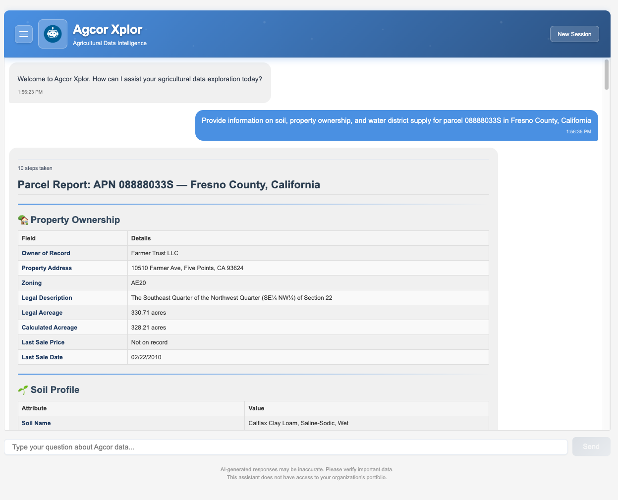
See the land tied to every loan. Flood zones, water risk, fire history, soil quality, water rights. Catch exposure before it shows up in a portfolio review.
2. Water as a credit signal
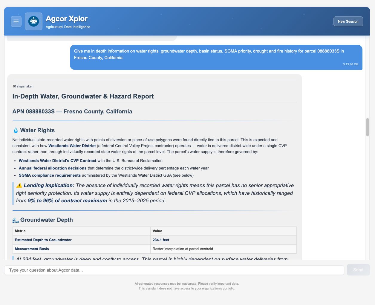
Water rights, groundwater depth, basin status, SGMA priority, drought and fire history. Built deepest where water decides the deal.
3. Decisions in minutes
Borrower, property, and market lookup in minutes instead of days. Audit-ready reports in one click.
4. Portfolio direction
Find new lending opportunities. Layer ownership, crop mix, and parcel data to identify properties that fit your underwriting box. Marketing builds outreach lists from the same data.
5. Data that keeps up
New datasets and analytics added over time so the platform doesn’t go stale. Federal, state, and regional sources rolled in as they become available.
The simplest way to analyze data.
The simplest way to analyze data.
Xplor turns the Agcor data warehouse into a chat interface. Same data. No clicks. No training curve.
Xplor delivers:
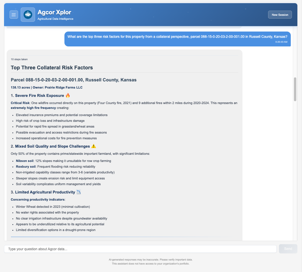
- Answers without analysts. Type a question. Get charts, tables, and a written summary in seconds.
- The lookup that used to take three phone calls: “Pull up parcel 12-345-678. Soil, water rights, ownership, recent crops.”
- The portfolio question they didn’t know they could ask: “Which of my California borrowers have parcels in SGMA-restricted basins?”
- The Midwest question for the corn-and-soy book: “Show me corn and soy borrowers in Iowa with parcels in counties that lost over 20% of yield in the last drought cycle.”
- Cross-data answers, no manual joins. Xplor correlates parcels with water rights, crops, soils, districts, environmental constraints, and fire history. No SQL, no analyst.
- Lines of thinking that carry over. Follow-up questions stay in context. Sessions save automatically.
For credit, risk, and marketing teams who want answers from the data without learning GIS.
How Agcor is packaged
Contact us today for a demo
How lenders actually use it
The borrower meeting
Loan officer pulls parcel-level soil, ownership, and water data while the borrower is in the room. Approval moves several days faster.
The flood map update
FEMA releases a revised flood map. Risk officer flags exposed borrowers in minutes. Relationship managers reach out before the next storm.
The audit prep
Compliance lead pulls audit-ready reports on loans in environmentally sensitive areas. Hours saved per audit.
The outreach campaign
Marketing builds a list of borrowers in fire-affected counties and runs a tailored campaign. Owners get a call from someone who already knows their situation.
The appraiser’s workflow
Appraiser pulls historical land use, parcel records, and satellite imagery from one platform. No exporting between tools.
Data and Trust
Lender-grade data sources.
- USDA NASS, USDA SSURGO (soils), USDA CDL (10 years of crop history)
- Multi-state Water Regulation (water rights, water district supply and delivery, SGMA)
- USFWS, USGS, NIFC (wildfire history)
- State water agencies, UC Davis
- 100+ curated datasets total
Security and privacy.
- SOC 2, Type 2 audited, our platform protects your sensitive data with advanced security protocols.
- Data encryption, security monitoring, and alerting.
- We don’t sell or market your data to third parties.
Testimonials
What our customers say
I have been continually impressed with the commitment to customer service. We use the Marketing and Sales Intelligence tool and at our request, Agcor expanded the information covered. This eliminated the need to visit multiple websites to gather information and we’ve been happy with the result!
Working with Agcor will allow us to make sure we are asking the right questions to borrowers to make sure they are prepared for the changes we are seeing in the ag industry.
Using Agcor has helped me cut down on research time and has provided me with more information than ever before! It is now the first step in my loan underwriting process and it has allowed me to devote more time toward expanding our loan portfolio.
Ready to lend with confidence on every acre?
